Beginning at the fluvial beach, Aboadela, the Pr2 "São Bento Walk", unwinds along a 12-km circuit, through the parishes of Aboadela, Sanche, Ôlo, Vila Chã and Gondar.
After passing through the Sanche parish, we arrive at Cruzeiro, Gondar.
The route passes over a section of the old Roman road, near the Marancinho stream, where a Roman pier can still be seen over the stream. Later, a steep track takes us to the top of the mountain, at an altitude of 550 meters, to a place called Picotos.
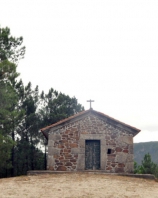
From the top, we can see the Terras de Basto region on one side and on the other, in successive layers of topography, the Marão and Aboboreira ranges. We follow onto the summit of the mountain until we come across a centuries-old path, about 1,500 meters further on. After passing by the ruins of an ancient inn, which served travellers and muleteers on their long and taxing journeys across the Marão, we climb up a path that runs over an old medieval road, and onto the S. Bento chapel. Later, we start our descent over forest trails that wind down the slope into the Aboadela Valley until we come across, in the valley itself, an old trail that takes us up to the Ovelha River. Crossing the river and the Ip4, we finally arrive at one of the highest points on this route - the Ovelha do Marão. This place, whose origins have been lost to time, is the most emblematic part of this route. Steeped in history and lore, it is an architectural assemblage that surprises visitors for its simplicity and rusticity.
With our visit to this historical place over, we return to our starting point.
Information:
Start and Finish: Rua - Aboadela
Type of Experience: Sports, cultural history, environment and landscape
Type of Trail: Secondary, rural trails
Distance to walk: 12 km, circuit
Duration of hike: About 3 hours
Topography: Not very steep
Degree of Difficulty: Medium
Best time of year: All year round
Location: Amarante


