Since the beginning of the 20th century, the “Mines Manifests” have declared several areas of mineral interest in the Regoufe region, which in 9 January 1915 obtains the exploration license for the denominated “Regoufe mine” or “Poça da Caldeira”, under the jurisdiction of a French man, Gustave Thomas. The Regoufe W-Sn field is located at the southeast edge of the homonymous plutonite, where the wolframite is the most abundant ore, occurring also some cassiterite. There are also some sulfides, such as the arsenopyrite, the sphalerite and the pyrite. There are also other minerals of less relevance, such as the bismuthinite, limonite, scorodite, autunite and bindheimite. Among the silicate minerals that support the mineralization, quartz stands out, followed by some muscovite, beryl and apatite.
In 1941, during the World War II, the main exploring company of Regoufe, Companhia Portuguesa is established, and it worked essential with British capital and administration. It was known as the “British Company” and it was responsible for some of the improvements in the region, such as the opening of a road from Ponte de Telhe, the electricity installation and telephone in the mines. The gap between the investments of both companies is obvious, once the British needed less and less Portuguese tungsten for the war.
The “Poça da Cadela” has a W-Sn exploration area of about 57 ha and it integrates the technical and administrative installations, the residences and the several entrances of galleries. It was the most profitable concession of Regoufe. Here we can find several galleries and heaps spread throughout the entire central area.
This mining pole is clearly delimited from the traditional agricultural village, which is a few meters away. The ruins and the almost monochrome tones of the granite fill in a wide abandoned village, but strangely modern, where just only one or another goat herd appears in the slopes and breaks the silence
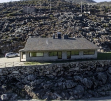
The nucleus of the mining complex where the constructions alternate with the mines entrances is arranged like an amphitheater around a relatively flat area, from where there are some water lines running. From the north and northeast side, it is possible to observe the technical and administrative facilities, with special emphasis on the two floor building at north, composed by the offices, occupying a kind of square, and that is surrounded by an entire set of constructions spread throughout the slope, destined to garages, electric station, warehouses, etc. The plant facilities, tanks and machinery are virtually the last of the complex, at southwest. At the opposite side, most of the constructions had a residential purpose, with special reference to the “neighborhood”, characterized by small compartments, aligned and arranged in a double platform, constituting the “houses of the miners”. It is still possible to identify the sanitary facilities, the “club”, a tavern and even a small horse stable.
Location: Arouca


