


Municipality: Arcos de Valdevez
Starting point: EN202 in Carregadouro | Jolda S. Paio
Arrival: Sistelo |Close on Castelo
Length: 32 500 metres
Acessibility: From the EN202, EN101 e EM505 and also using several existing routes
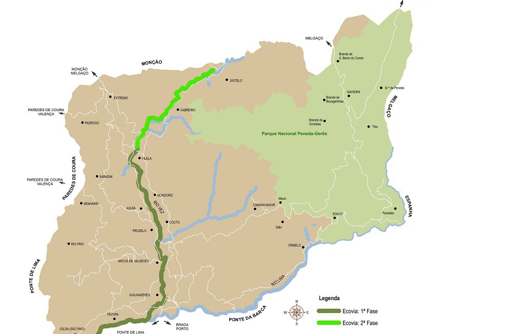
The pathway develops itself along the rivers Lima and Vez, for a total length of 32, 5 Km. At the river Lima: from the right bank of the municipal limit, in S. Paio de Jolda till the place of Gandara, Santar’s village; at the river Vez: from the right bank, bounded to the north by the Sistelo village and to the south by the place of Prova, to Paço’s village. The implementation of the pathway, offers ideal exploitation conditions, in complete respect for the environment, by returning to the inhabitants of the municipality an unmatched quality area. It took into account the representation that a course of this kind can provide at the Arcos de Valdevez as well as their intricate link with its surrounding, promoting the protection, recovery, cultural and architectural preservation as well as ecological and nature values enforcement. For this reason, we opted for the deployment of an essentially rural or natural route, despite the existence of some sections in urban areas, this situation diversifies potential track users, thus covering the daily and end-of-week use, as well as tourists whose use habits are seasonal.
Points of touristic interest
Banks of river Vez,
Banks of river Lima,
Vilela Bridge,
Estrica belvedere,
Sistelo Castle
Urban centre of Arcos de Valdevez.
Location: Arcos de Valdevez
Starting point: EN202 in Carregadouro | Jolda S. Paio
Arrival: Sistelo |Close on Castelo
Length: 32 500 metres
Acessibility: From the EN202, EN101 e EM505 and also using several existing routes
The pathway develops itself along the rivers Lima and Vez, for a total length of 32, 5 Km. At the river Lima: from the right bank of the municipal limit, in S. Paio de Jolda till the place of Gandara, Santar’s village; at the river Vez: from the right bank, bounded to the north by the Sistelo village and to the south by the place of Prova, to Paço’s village. The implementation of the pathway, offers ideal exploitation conditions, in complete respect for the environment, by returning to the inhabitants of the municipality an unmatched quality area. It took into account the representation that a course of this kind can provide at the Arcos de Valdevez as well as their intricate link with its surrounding, promoting the protection, recovery, cultural and architectural preservation as well as ecological and nature values enforcement. For this reason, we opted for the deployment of an essentially rural or natural route, despite the existence of some sections in urban areas, this situation diversifies potential track users, thus covering the daily and end-of-week use, as well as tourists whose use habits are seasonal.
Points of touristic interest
Banks of river Vez,
Banks of river Lima,
Vilela Bridge,
Estrica belvedere,
Sistelo Castle
Urban centre of Arcos de Valdevez.
Location: Arcos de Valdevez