(PR2 - SHORT ROUTE PATH 2)
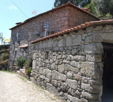
The Trail of Urjal runs through the rural villages of Urjal and Chã Grande forming a short route path (PR). It has a length of 14 km, with an average duration of 4 hours with a moderate degree of difficulty. The maximum altimetry height of 683 m will be reached near the Penedo das Cadeiras, and the lower level of 269 m, in Reposinhas.
This trail expressed into a rural route that provides a recognition of the usefulness of standing narrow paths, agricultural pathways and water mills, which together constitute genuine relics of the rural architecture of ancient times that remain to this day.
The landscape that surrounds this route is typically mountainous, characterized by mixed areas, alternating between forest stands of conifers, eucalyptus and oak trees and areas adjacent to villages, where agricultural terraces can be found. The pathway also offers us a great diversity of species of plants and animals.
The Trail of Urjal provides its visitors observing points of unique nature, including a panoramic view of the Cávado Valley.
Location: Amares